
Plan Change 120
Plan Change 120 Explained: What Auckland’s Future Housing Plan Means for Property Owners
Plan Change 120 (PC120) proposes significant changes to how Auckland will accommodate future housing growth. With submissions closing on 19 December, now is the time to understand what is being proposed, where change is focused, and how you can engage with the process.
At Agents of Architecture, we see PC120 as an important shift toward more deliberate, infrastructure-led intensification. This article outlines what is changing, where to find accurate information, and how the proposals may influence future site potential and design outcomes.

What Is Plan Change 120?
PC120 updates Auckland’s planning framework to concentrate higher-density housing in locations that are well supported by public transport, centres, and existing infrastructure. At the same time, it reflects updated natural hazard information, which has already resulted in changes to planning controls in some areas.
Rather than applying density uniformly across the city, PC120 focuses growth where it is most sustainable and limits intensification in higher-risk locations.
Where Intensification Is Being Directed
Under PC120, increased building heights and density are generally focused around:
Train stations, including CRL-connected stations
Metropolitan, town, and local centres
Frequent bus corridors
Across the isthmus and key growth areas, this translates to a range of permitted building heights, from low-rise neighbourhoods through to mid-rise and, in select locations, high-rise development.
How to Check What Applies to Your Property
If you are reviewing how PC120 may affect your area, we recommend referring to Council’s dedicated website and using some of the interactive tools. There is a lot of information provided and in many different places so it can be confusing as to what to look at, so we have simplified it for you:
1. Read the Plan Change Overview
This page provides background, rationale, and supporting information Auckland's Future Housing Plan - Plan Change 120
This is where all the information can be found, so if you are wanted to read it all, look here. There are some helpful videos to understand the overall picture of PC120.
2. View the interactive plan
There is a user guide for this map, but we suggest typing in your address to see your property and the surrounding area. Look for your and surrounding sites Zone/s, Management Layer/s, and Spatially Identified Qualifying Matter/s that may affect your property.
To find out more about the changes, refer to PC120: Housing Intensification and Resilience, and scroll down to Plan Change Documents.
Under Background there are summary PC 120 Info Sheets for each zones to give a high-level understanding of the changes. For the full details of PC120 refer to the Notification Documents.
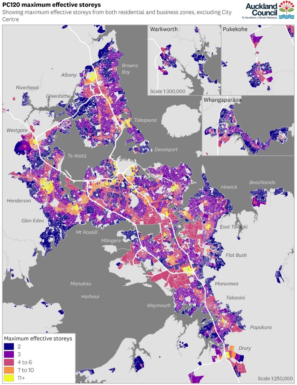
3. Housing Capacity Modelling Report
The Housing Capacity Modelling Report compares the existing PC78 with the proposed PC120.
Very useful maps found on pages 32, 33, & 34 compare the plan change Maximum effective storeys to understand what is enabled in different locations.
4. Make a Submission (by 19 December)
Submissions can be made directly through the Council website Unitary Plan Submission Form
Submissions do not need to be lengthy, even short, site-specific feedback is valuable.
Natural Hazard Planning Changes
It is important to note that many natural hazard planning changes have already taken effect. These include updated flood, coastal, and land stability overlays.
While PC120 responds to these constraints in its zoning approach, the hazard controls themselves are already operative. This means:
Some development limitations are already in place
Mitigation and design response are now critical considerations
Future projects need to address risk early and clearly
What This Means for Future Development
PC120 does not mandate development, but it does influence what may be possible over time. For some sites, it may unlock additional height or density. For others, it reinforces the need for careful, site-responsive design.
Understanding site potential is not just about zoning — it also involves:
Site configuration and access
Context and interface with neighbours
Infrastructure capacity
Natural hazard constraints
Market demand and building typology
Our Role as Architects
At Agents of Architecture, we collaborate closely with planners to ensure planning controls, design intent, and technical performance are aligned from the outset.
Our role typically focuses on:
Exploring site potential through early design thinking
Testing building form, scale, and massing
Developing resilient design responses in hazard-affected areas
Supporting coordinated outcomes between client, planner, and consultant team
This collaborative approach helps ensure future projects are realistic, compliant, and well-considered.
Looking Ahead
Plan Change 120 is part of a longer-term shift in how Auckland grows. While submissions close shortly, the implications of these changes will play out over many years.
For property owners and project teams, the key is not urgency but understanding. Knowing what is proposed, where to find reliable information, and how planning and design work together, is essential to making informed decisions about the future.
Please contact us if you have questions or would like to explore the potential for your property.
For a deeper look at how urban intensification is reshaping how we build, our previous Designing for Density article explores this topic in more detail.